Sunday, 19 June 2011

Hendry Park and Trout Lake

John Hendry Park, better known by the locals as (Vancouver's) Trout Lake, was the former site of Hastings Mill. The mill, owned by city maverick John Hendry, was the very first within city boundaries. Hendry chose this location because the adjacent lake between the Fraser River and the Burrard Inlet was perfect to supply power to his mill. A man of means and vision, he purchased the area just prior to the arrival of the railroad. He would later step back from the lumber business and become a railroad baron. He continued to own the land, passing it to his daughter and her husband in 1916. By 1920 the mill had been closed and in 1926 the Hambers donated the land to the city as a park with the provision that it be named after Mrs Hamber's late father. I don't know why the name never caught on and why it is still called Trout Lake because there are no recorded sightings of trout since before the second world war.

Lots of open fields
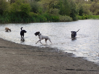
The north end of the lake is an off leash dog area
Humans are allowed to swim on the south side
BBQs are permitted but not provided
Personally I would not swim in the lake as it is often closed due to high fecal coliform levels. But safe swimming will soon be possible with the opening of an aquatic centre with in and outdoor facilities. This will be attached to newly designed community centre sports complex.


This new Trout Lake Community Centre has been years in the making and is a part of the Vancouver 2010 Olympic/Paralympic legacy. It was used as a training centre for the figure skaters and sledge hockey players during the games. This state of the art multi-use centre will certainly be the highlight of the park when it is completed in the fall of 2011. The current centre continues to operate with limited programing until then.

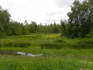
The south and west sides of Trout Lake are left wilder
Harry Whitehead has been coming to the park since 1935
Play areas can be accessed but there is no adaptive equipment
As it stands now the park is fairly accessible. The washrooms at the beach house are accessible, and most of the trails and lookout points are equally as inviting.  There are soccer fields and baseball diamonds with accessible clubhouse facilities. By the way, the City of Vancouver has posted an accessible trail guide on their website. Check out accessible hiking trails at this and other city parks at www.vancouver.ca/parks/activecommunity/walks.htm

The biggest drawback is getting to the park. Although it is very close to the Commercial/Broadway skytrain station walking there is a bit hazardous. Commercial Drive is an accessible street with proper crosswalks, curb cuts, etc but when you need to turn off it to walk to the park, safety is questionable. Several of the side streets are badly in need of an upgrade. Better to book a HandyDart if you can, or drive. Parking lots at the south and north end of the park have disability parking. On Saturdays through the summer the north parking lot hosts a fantastic farmers' market. For information on transit including HandyDart and trip planning go to www.translink.ca

Wednesday, 15 June 2011

Van Dusen Gardens growing more accessible


This former home of the Shaughnessy Golf Course is now a beautiful 55 acre oasis in the heart Vancouver. The city run garden was first opened in 1975 and is now in the midst of a 20 million dollar face lift. One of its major new attractions is scheduled to open in September 2011: a newly built Visitor Centre. Much is being made of the new structure and its living building philosophy. The phrase is used to define very high environmental standards, and is governed buy a set of principles that mandates indoor quality that is "healthy for all people."  For people with disabilities this is fantastic news. Current old buildings and grounds are only modestly accessible.

This accessibility logo at the Education Centre belongs on the fertilizer pile

Washrooms are sparse and inadequate. I found only one truly accessible facility, a porta-potty located near the great lawn. As mentioned improvements are underway with newly landscaped pathways, viewing decks and a pavilion for the great lawn area of the garden coming soon. Accessibility in the higher regions of the garden needs some attention. For example cobblestone at the base of the waterfall, one of the garden's highlights, is neither natural nor necessary and makes for bumpy ride or tripping hazard. There is a tram that has scheduled runs to all regions of the park, but it does not provide independent access. Way finding also needs improvement with better marked trails, larger signs and tactile trailways.

 This Korean gift was added to the garden after Expo 86

Thousands of colours create a magical experience during the yuletide Festival of Light
The garden is year around home to many cultural, educational and fun events. I have always loved this place in spite of its accessibillity shortcomings. When I made the transition from walker to scooter it was one of the first places I came to try out my new wheels.

This tram has sturdy holding rails for loading and unloading 
Lots of paved trails in the lower levels of the garden
Former garden volunteer Viola Chan still loves to visit

Plenty of benches

The garden is home to several permanent and touring sculpture exhibits

Vandusen Gardens recognizes the Access 2 entertainment program http://www.easterseals.ca/ which allows attendants/companions free access to a variety of theatres and attractions across Canada. While you're on that website, check out the disability travel card for the same deal on many buses and trains. For directions to the garden, event information, fees and more go to http://www.vandusengarden.org/.

Sunday, 12 June 2011

Hiking the dykes along an ocean island estuary

Richmond BC is made up of a group of islands connected by bridges
Where the Fraser, one the world's fastest flowing rivers, arrives at the Pacific Ocean, two large islands and a group of smaller ones are connected by roads and bridges to form the City of Richmond. The fresh and salt water mix of the Fraser and Pacific gives it the area the title of estuary.

Today we travel a small section of this 80+ km  dyke along the very accessible Bridgeport Trail, the not very accessible Middle Arm Trail and the moderately accessible West Dyke Trail. We begin the trip at Aberdeen Canada Line skytrain station. For directions go to http://www.translink.ca/ . From here it is 1500 m to the Richmond Oval. The Oval was one of the central attractions of the Vancouver 2010 Winter Olympics. Now it serves as a community centre/sports complex. For details check out http://www.richmondoval.ca/.

Getting to the dyke across No 3 Road is easy with very wide curb cuts, auditory crossings and tactile clues. We follow the sign that points us down Cambie Road to a crossing at River Road which consists only of curb cuts and a crosswalk made somewhat safer by a three way stop.  The Bridgeport section of trail has accessible washrooms, lighting, paved paths, places to sit, and a great play area for children of all abilities.


Motion sensitive devices release sounds
of seals, fog horns, and squawking gulls
Inclusive play areas with all abilities play equipment
The oval is huge and very accessible
Middle Arm Trail is not accomodating to PWDs

The area is a bird sanctuary

Beyond the Oval heading southwest the dyke takes us to the Middle Arm Trail. This section of trail is rustic and not adapted. Long grass makes accessing picnic tables and benches difficult to impossible. Pavement turns to gravel. You have to commit to long sections of dyke trail with no exit points save the occasional set of stairs or steep embankments. There is no transit or amenities in the immediate area and no washrooms until you reach Terra Nova Park.

Terra Nova Park is a great place to watch planes come and go
After Terra Nova Park we get to the West Dyke Trail. This section of dyke is still gravel, but with more washrooms and access to benches it rates higher marks than Middle Arm.

Sight lines at viewing platforms need lowering
Miles of mud flats and driftwood
The turnaround signs let you know how far you have gone, but provide no clues as to how far the next turnoff points would be. Turnoff points of  this 7 km section of dyke are spaced roughly 1 km apart. Keep in mind that you will have to travel another 500+ m to get to No 3 Road to reconnect with transit. You could take this trail all the way to Gary Point Park and the historical Steveston fishing village.  Gary Point Park and beyond is much more accessible with paved trails, bus route access, numerous accessible washrooms and other amenities. We will save that trip for another day.

Wednesday, 8 June 2011

Surrey Green Timbers has "reel a lure"


If something smells a little fishy as you read this, blame me. I can't resist all the literary devices that a good fishing story has to offer. It's like shooting fish in a barrel. Ever since I was invited to the 20th annual Fish for Life derby, I have been dreaming of the succulent taste of fresh grilled trout. The sizzle as the outer skin crackles above the heat of hot coals, a drizzle of olive oil, some sea salt, pepper and lemon. Nothing tastes as good. But before we cast our lines in that direction, here are a few nibbles about the park.
Newly restored wetlands

Lots of accessible groomed trails to hike

I love these wheelchair adapted picnic tables

Surrey has a long been the butt of jokes. Traffic happy neighbourhoods where streets are more highway than road, crime, low income run down areas and distance from the heart of Vancouver have all provided fodder. But of late Surrey is enjoying a renaissance and is now one of BC's fasting growing cities. A new downtown core is being constructed complete with community square, recreation centre and newly added Simon Fraser University Campus. This reconstructed heart of the city is located near the King George skytrain station situated a mile or less from beautiful Surrey Green Timbers Park.

The area known as Green Timbers Urban Forest was the original site of the Yale Wagon Road, the main route that connected the west coast with the interior in the 1800s. As early as 1860, attempts were made to have this area designated as a park. In spite of these efforts the magnificent, pristine virgin forest was completely clear cut by the late 1920s. In 1930 Canada's first documented attempt at reforestation got underway. This area had long been a battleground between conservationists and developers. In 1987 the fight culminated in the incorporation of  the 1000 folks-strong Green Timbers Heritage Society.  The Society managed to protect 42 acres and in 1988 this urban forest was reborn. Through persistence and government lobbying, a further 53.3 acres were secured. The rest of the rainforest is managed by BC's Ministry of Forests but is not yet a completely declared protected greenbelt. For more information on the Green Timbers Heritage Society, including a list of  programs and events such as nature walks, easter egg hunts and more, go to http://www.greentimbers.ca./ The Nature House is under extensive renovations and promises to be as inclusive as this extremely accessible park.


Getting there I opt for a shared transit/taxi ride. I usually rely solely on Translink's remarkably accessible transit system, but as you travel east, service across the board is less and less accommodating. The park could be walkable from the King George Highway station in future when development is complete. The early reviews are fantastic. Surrey has made a real effort to accommodate people with disabilities. What was 7+ years ago a death defying attempt at crossing the King George Highway (scary enough to make the King himself redevelop his stammer) is now literally a very pleasant walk in the park with all the latest in way finding and crossing access.  However, beyond the immediate development we are back to large highway-like avenues and roads, construction, poor curb cuts, treacherous crossings and bus stops that are far less inviting than the park. The taxi on the way there got lost and we spent $17.50 getting to the park as opposed to $7.50 on the return trip. To avoid feeling like a sucker who took the bait, you should specifically request the entrance at 100 Ave and 144 Street. If you are driving, go to the same entrance.because the lot has designated parking spots for PWDs. The washrooms are great though scarce and many of the trails are easy to traverse and well marked with plenty of places to sit.


Lets' get back to those succulent pink fleshed rainbow trout. The host for the derby is a group of volunteer anglers called Fishing forever and the BC Wild Life Federation. They are a fantastic group of people who clearly work very hard to put on this thoughtfully planned event. When they say they will provide you with everything you need you can trust them. Fishing pole, bait, licence, sunscreen and lunch were all provided. They even provided breakfast in the form of Tim's donuts, the fuel of any great Canadian fishing expedition. If that's not enough a free cap and a cool t-shirt (and trophies for the winners) were also part of the haul.


Over 75 of us kept event coordinator Rob Ausma and a congenial group of helpers busy with baiting hooks, untangling lines, teaching to cast, serving lunch, bandaging barbs, and way finding. They did all of these tasks with the utmost respect and were very free to let us find our own way. Unless this man-made lake freezes over, you can fish year round. Be sure to obey all rules and get a licence. For rules, licences and information on discounts for PWDs go to http://www.fishing.gov.bc.ca/ .

In the end it didn't matter who won the trophies, but for the record here they are: Ed Yee for catching the first fish, Glen Burrant for catching two fish (junior category) and Ivan Ngai who also caught his quota of two fish.


 As for me, a baby bald eagle ripped an eight pounder right from my hands.

Sunday, 5 June 2011

Going north -- shore that is. Swimmin' pools, movie stars

You can go by bridge or boat
  
The seabus is part of Translink the public transit provider
This yacht moored at North Vancouver's Lonsdale Quay is not
OK, if you have been reading my last couple of blog posts you might think the ship has sailed on yet another boat trip story. But since the only way from the City of Vancouver across the Burrard Inlet to the multi municipality of the District of North Vancouver, the City of North Vancouver and the District of West Vancouver is by bridge or boat, ahoy, mates!

Why are there three municipal governments in such a small area? The settlement started as a sawmill owned by a fellow named Moody. Eventually the mill attracted a large enough population to form a small village known as Moodyville. Being Moody is a bummer, so in 1891 some folks split and formed the District of North Vancouver. Eventually a hotel, a bank, and electricity arrived. The people living in the area now known as Lower Lonsdale did not want to pay infrasatructure costs for the people living in the of the area now known as the City of North Vancouver. So in 1907 the cast-off citizens incorporated into the City of North Vancouver. Similarly, when in 1912 the infrastructure cost issue arose for the City of North Vancouver, the District of West Vancouver was born. Today West Vancouver is home to the British Properties, some of the most expensive real estate on earth. As for those Moody settlers they amalgamated with the District of North Vancouver in 1915. Today all three municipalities have a good working relationship.

There are two bridges over the Burrard Inlet: the iconic Lions Gate Bridge and the Ironworkers Memorial Bridge. The memorial is to the 19 workers who died during its construction. Both bridges are frequently backed up, threatened by tolls,  and subject to complete closure. Avoid them and opt for a smooth sail across the inlet. As usual I start my trip on our fully accessible transit system with the trip planner at http://www.translink.ca/ . It guides me to the major transit hub at Waterfront Station where the Westcoast Express, all skytrain lines, sea bus, and several trolley and bus routes connect. The seabus terminal is a little lacking and needs an upgrade to be as accessible as a world class transit system in a world class city should be. The only washrooms situated on the dock are old and not  accessible and the elevator is old, small and frequently out of service causing a time consuming detour involving a HandyDart trip to the boat that takes three times longer than the 12 minute seabus crossing. On board the aisles are wide and the disability areas are well marked. Unfortunately the older boats have stickers at the wheelchair sight lines, but the new craft are dramatically improved with more sight lines and wider aisles.


The seabus deposits you at the Lonsdale Quay, another transit hub. The immediate area is host to waterfront parks, piers, eateries, hotels, shopping and a newly refurbished historical ship yard. We will visit this and other areas that the north shore gateways including Grouse Mountain, the Capilano Dam, and Indian Arm in future blogs. For now a closer look at the market.

The market is accessible in the 1986 sort of sense. For example, it has only a few automatic doors and the elevators are not auditory. Most of  the aisles are wide enough, the market grounds around the harbour can be accessed albeit by circuitous routes and the washrooms each have a big accessible stall after you battle a couple of heavy clunky doors, with a sharp turn thrown in for good measure.  For all of that it is still a fun place to visit. From the front you can watch the goings on of a major world port. Helicopters and sea planes buzz about and ships of all sorts and sizes come and go from everywhere. The market itself has frequent entertainment, and has many great places to eat and drink or stock the larder with fresh fish, baked goods and other treats from around the world. For details check http://www.lonsdalequay.com/ .


Until next time when I report on my experience at the 20th annual Fishing Forever trout derby in Surrey's Green Timbers park.